Cartography is defined as the art of map-making and map-designing that ”integrates science, technology and visual aesthetics for the purposes of rendering the domain of interest, navigable” (Thomas & Zaytseva, 2016). The study of cartography, through history, provides valuable information about the development, the makers, the sources, ideas, theories as well as the technology implemented and characteristics of the final product (Thomas & Zaytseva, 2016; Bagrow, 2017).
A map, through the eyes of modern human, is seen as an object so common, in a standardized form which is automatically recognized from the mind. For instance, the mind is bale to automatically and instantly recognize the shape of a familiar landmark when the eyes come across it. Imagine seen the outline of Cyprus island on a mug, or a t-shirt. The mind instantly recognised the shape as the one of the physical space of Cyprus. A map is a form of language and communication. The term has traditionally defined as a graphic representation of “things” in space. Throughout the years and the development of cartography and map-design, the term ”things” became so vast; a map as a graphic representation can facilitate not only physical spaces but also concepts, perceptions, conditions, processes, events, etc (Robinson & Petchenik, 2011; Morrison, 2011; Thomas & Zaytseva, 2016). According to Robinson et al. (1995), cartography is the result of the intergradation of: (1) collection and selection of data, (2) the administration of data and design of the map, (3) the recognition of the map and (4) the transliteration/interpretation of “derived” information.
Cyprus cartography is a valuable source of information regarding ancient sites and localities as seen through the eyes of cartographers. At the same time, it provides important information on the perception of space, availability of sources, education, data acquisition and selection, and design of the cartographers as well as of people of different profession and background. Below, we present a few examples of cartography of Cyprus in which archaeological sites and locations are mentioned.
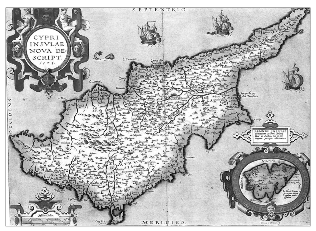
According to Iacovou (2004), the third quarter of the 16th century AD is the ”golden age” of Cypriot cartography. It is a period of conflicts between the Venetians and Ottomans, over Cyprus which fell under the Ottomans in 1571. The map of Giacomo Franco, published by Abraham Ortelius, “Cypri Insulae Nova Descript. 1573” is one of the masterpieces of this period, (Figure 1). The complete cartography presents Cyprus surrounded by nine Aegean Islands. This map determined the development of cartography for the following years as no other cartographer was able to design a better land-map of the island (Iacovou, 2000; 2004).
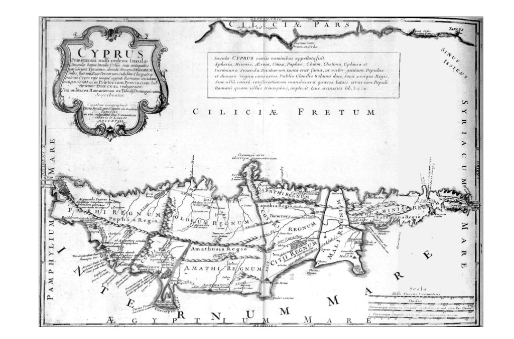
Among the most important maps of Cyprus is the one created by the European mapmaker, Pierre Moullart-Sanson, in 1718 AD, (Fig.2). In this map, Moullart-Sanson decided to deviate the island in four districts, based on the Ptolemaic prototype of the four ancient districts; Paphia, Salaminia, Lapithia and Amathusia. Moullart-Sanson includes in his map, nice ancient Cypriot Kingdoms and their (possible) boundaries, providing a remarkable source of information as well as influencing the development of cartography of Cyprus. The creation of the map relies on ancient sources, indicating that at the time that the map was created, Europe scholars had a profound knowledge of classical studies, access to ancient written sources and the skills to conduct scholarly research. This map contains the names and boundaries of nine ancient kingdoms (Iacovou, 2004).
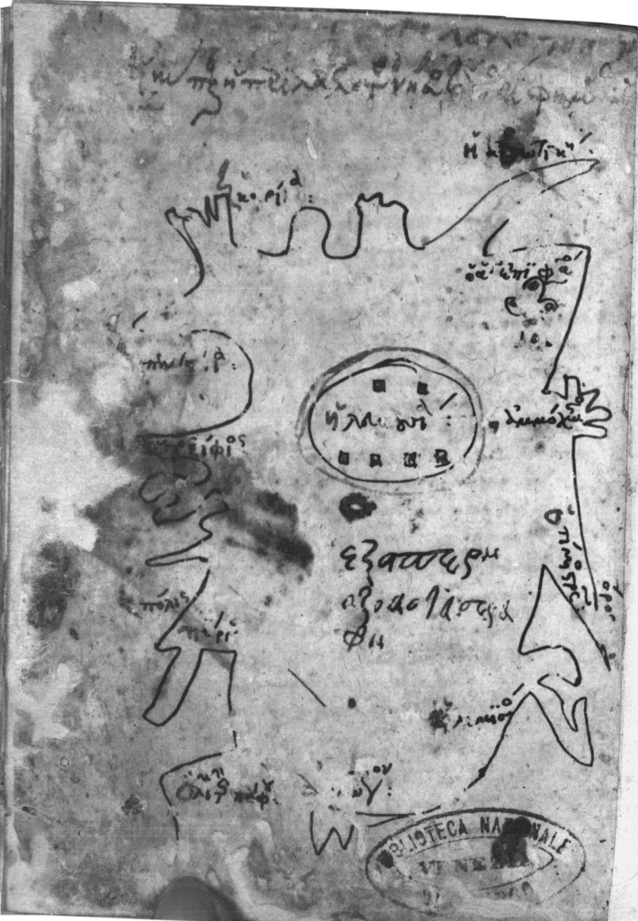
Of great interest is a schematic map of Cyprus dating to the 14th century AD. The original map and its copy were found in two Byzantine greek manuscripts (Milan, Biblioteca Ambrosiana, MS A 95 sup. and Venice, Biblioteca Nazionale Marciana, MS gr. XI.21, coll. 453). This map (Fig.3) was not created by a cartographer but likely by a physician who had collected the medical texts included in the manuscripts. The map is a schematic freehand creation of the island which includes some of the major locations and monuments and provides an evidence of the perception of the man (Cronier & Gautier Dalche, 2017).
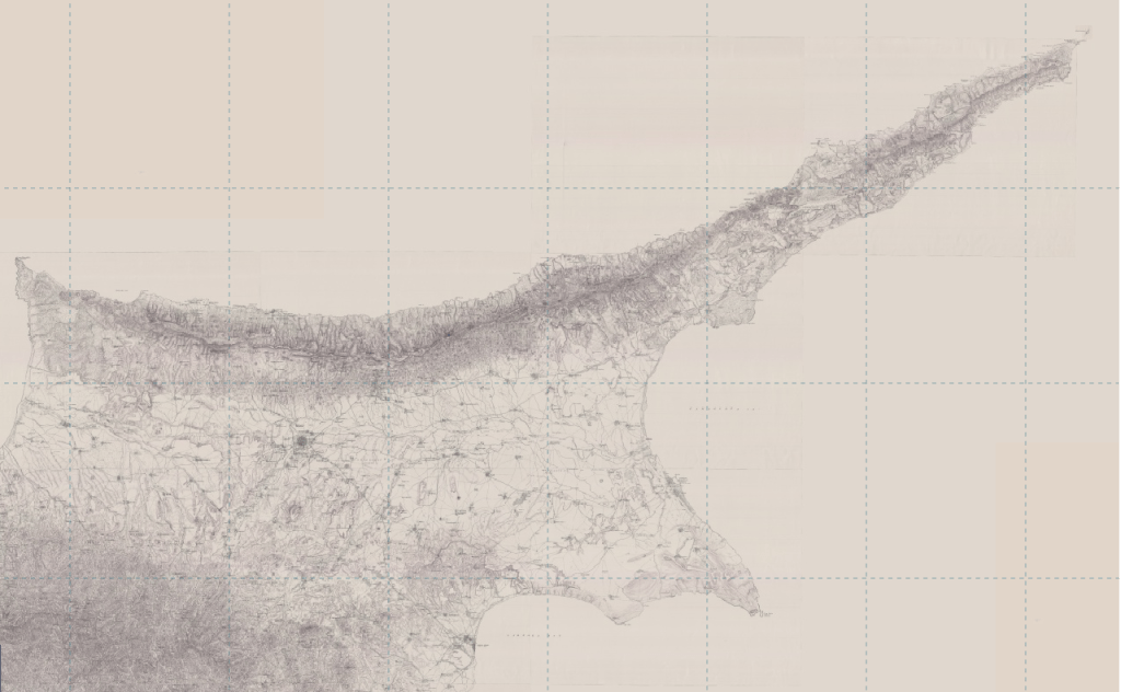
Undoubtedly, Kitchener’s survey of Cyprus (Featured Image at the top), the first complete trigonometrical survey of Cyprus, carried out in 1878-1882, is by far the most comprehensive cartography of Cyprus before the modern advanced applications and techniques. The map of Kitchener comprise a valuable tool, a source of information, in the hands of archaeologist, as it is a comprehensive documentation not just of the modern sites/localities but a documentation of ancient ruins, tombs, localities and more.
Research and Text: Cyprus Archaeology Team
Bibliography & Sources
Cronier M. & Gautier Dalche, P. A Map of Cyprus in Two Fourteenth-Century Byzantine Manuscripts. Imago Mundi, 69 (2),2: 176–187
Dodge, M., Kitchin, R. & Perkins, C. (eds.), ”The Map Reader: Theories of Mapping Practice and Cartographic Representation,” John Wiley & Sons, Ltd.
Iacovou, M. 2000. Mapping the Ancient Kingdoms of Cyprus. Cartography and Classical Scholarship during the Enlightenment. Eastern Mediterranean Cartographies, 263-285.
Iacovou Maria. European cartographers as classical scholars : Pierre Moullart-Sanson and his sources for the kingdoms of Cyprus. In: Cahiers du Centre d’Etudes Chypriotes. 30, 79-94
Morrison J.L. 2011. The Science of Cartography and its Essential Processes, In M. Dodge, R. Kitchin, & C. Perkins, (eds.), ”The Map Reader: Theories of Mapping Practice and Cartographic Representation,” John Wiley & Sons, Ltd.
Talbert, R.J.A. & Unger, R.W. 2008. Cartography in Antiquity and
the Middle Ages: Fresh Perspectives, New Methods, Brill, Leiden-Boston.
Robinson, A.H. & Petchenik, B.B. 2011. On Maps and Mapping, from The Nature of Maps: Essays Toward Understanding Maps and Mapping. In M. Dodge, R. Kitchin, & C. Perkins, (eds.), ”The Map Reader: Theories of Mapping Practice and Cartographic Representation,” John Wiley & Sons, Ltd.
Robinson A., Morrison J., Muehrcke P., Kimerling A., & Guptill S. 1995. Elements of Cartography. John Wiley & Sons, Inc.


