Kalavasos- Ayios Dhmitrios was a major Late Cypriot city situated in the in the south coast of Cyprus, between the districts of Limassol and Larnaca and it is the largest settlement of the Kalavasos-Maroni area. The site has been extensively excavated. It was a well-planned settlement, about 12 hectares, laid out on an orthogonal plan. Excavations in the area revealed a series of structures and a large number of tombs, indicating an occupation which dates between 1450-1200 BC.
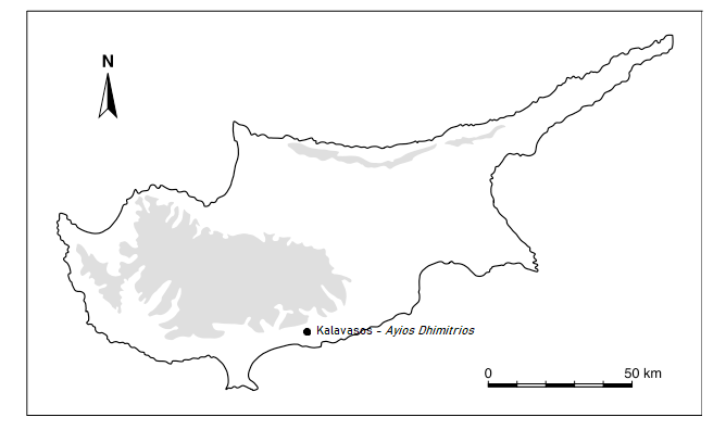
Agios Dhimitrios is situated in the south coast of Cyprus, in Larnaka District. It is located just next to the Neolithic site of Kalavasos-Tenta. It is one of the major Late Cypriot cities. It is also the largest settlement of the Kalavasos-Maroni area.
History of Excavations
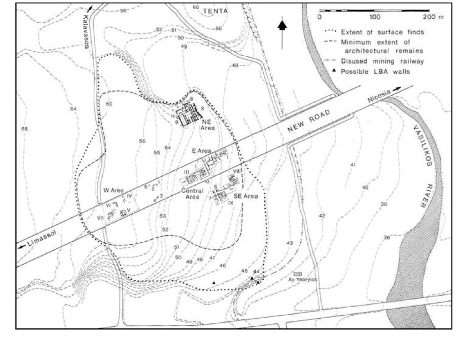
The excavations at Kalavasos- Ayios Dhimitrios took place between 1979 and 1998 under the direction of Alison South and Ian Todd as part of the research of the Vasilikos Valley Project. The excavations focused on five areas of the site and the revealed a Late Cypriot II urban center that by the LC IIC reached its zenith. The excavations revealed impressive architecture, a sophisticated city-planning with streets, large ashlar buildings and domestic houses (South and Todd, 1985; South, 2002; 2012; Fisher et al., 2019).
The archaeology
Ayios Dhimitrios occupied throughout the Late Cypriot (LC) IIA (1450-1340/1325 BC) to LC IIC (1340/1325-1200 BC) and was abandoned around 1200 BC. The site provided evidence of the existence of sophisticated town planning, architectural design and ashlar masonry as well as evidence of international trade. The city was part of a trade network in the region, involved in copper trade, manufacture and distribution of luxury goods and use of literacy and organization of large-scale agriculture production. It is thought that its abandonment could have been the result of the effects of a climate change around 1200 BC.
The ancient city took its name from the modern locality. It is part of the Vasilikos River Valley and its situated 3.5 km from the coast. It is situated on a gently sloping river terrace, next to the marls and gravels of the flood plain in the wide lower part of the Vasilikos River and in close proximity to the Kalavasos rich ore-bodies and mining area. The site has a key location within the area, at the crossroads of the natural route along the coastal plain. Its location served as a crossroad linking the central and eastern Cyprus with the western territories and the north-south route through the valley that links the copper mines in the Troodos mountains to the sea. This likely enabled communication and trade in the region to be developed (South & Todd, 1985; South and Todd, 1985; South, 2012; Fisher et al., 2019).
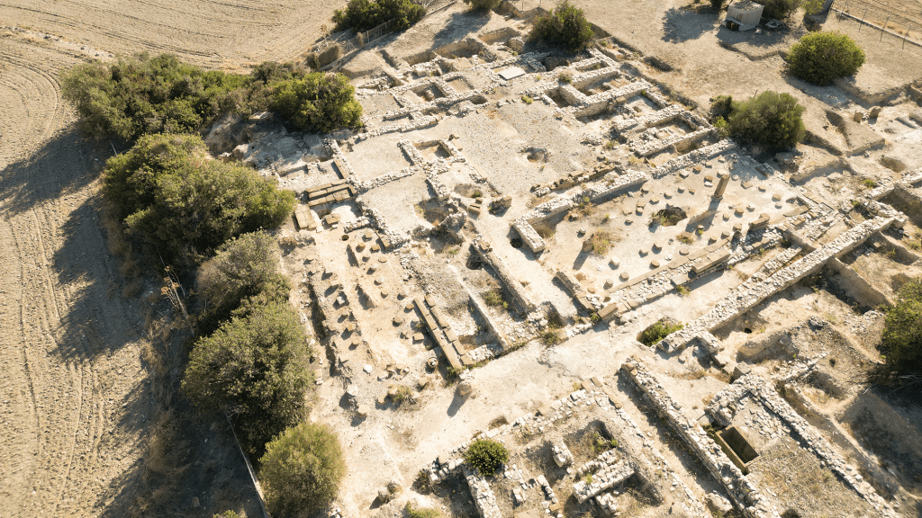
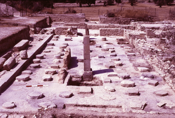
The excavations revealed a variety of types of structures; domestic, industrial and administrating buildings, all on the same orientation. Several of these structures were constructed with ashlar masonry (Figure 3). The settlement’s plan includes several streets, all provided with drains to carry away rain water. The road system includes one major north-south road about 150 m and one or more transverse east-west streets (South, 2002; South, 2012; Fisher et al. 2019).
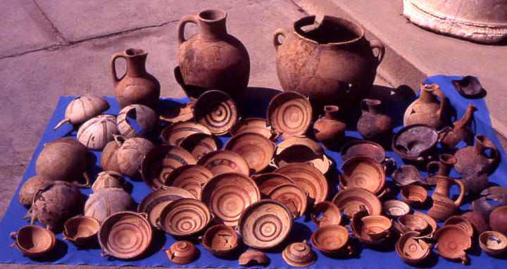
Elite structures were excavated in the East, Central and Southeast Areas of the city. These structures are mutli-roomed buildings of 100-600 m2 and they had domestic character and function. The material found in them is consisted mostly of Cypriot material and few imports such as Mycenaean pottery, Canaanite jars, imported stone objects and few cylinder and stamp seals. One of the structures yield evidence of small-scale copper-smithing work. The finds include fragments of oxide ingots. Copper slags and other finds excavated in the area indicate that metallurgical activity was performed at the site, in small scale though (South, 2002).
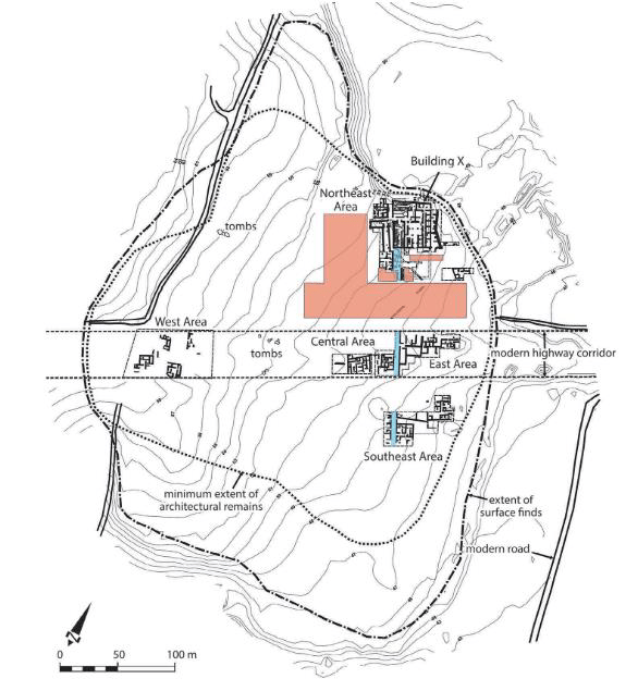
The North Area consists of a group of large administrative and industrial complexes, dominated by Building X, the principal structure, which housed extensive installations for storing olive oil. In contrast, the South and West sectors of the settlement are characterized by smaller, more domestic buildings, while the eastern and central zones appear to have supported various small‑scale activities (South 1997; 2012).
Building X, located in the northern sector of the city, is a monumental, square structure organized around a central courtyard and designed with a tripartite layout. Covering roughly 1,000 m², it was built sometime after LC IIA using ashlar masonry—especially visible on its exterior walls, the courtyard, and select architectural features—and likely rose to two storeys. Finds from within the building include stamp seals and clay cylinders bearing Cypro‑Minoan inscriptions, indicating that administrative functions took place there. The ceramic assemblage consists of both locally produced vessels and imported wares. Room 152, known as the “Pithos Hall,” yielded numerous small and large pithoi. Gas Chromatography analyses show that several of these once held olive oil, with a combined storage capacity reaching approximately 35,500 liters. Facilities associated with olive‑oil production have been identified in the adjacent Building XI. Nearby, Building IX was interpreted by the excavators as a workshop dedicated to small‑scale copper smithing.
The inhabitants of Ayios Dhimitrios participated in a wide range of economic activities, including agriculture, copper working and metallurgy, animal husbandry, and pottery production. Excavated evidence indicates the cultivation of olives, wheat, barley, lentils, and grapes in the surrounding area. Figs were also gathered, although it remains uncertain whether they were domesticated (Hanse, 1989).
The site has a key location within the area, at the crossroads of the natural route along the coastal plain. Its location served as a crossroad linking the central and eastern Cyprus with the western territories and the north-south route through the valley that links the copper mines in the Troodos mountains to the sea. This enabled communication and trade in the region to be developed (South & Todd, 1985; South and Todd, 1985; South, 2012; Fisher et al., 2019).
The archaeological evidence from Ayios Dhimitrios enabled our understanding of the development of a complex society in Cyprus during the Late Bronze Age. The site provided evidence of the existence of sophisticated town planning, architectural design and ashlar masonry as well as the influence of international trade. Ayios Dhimitrios was part of a trade network in the region, involved in copper trade, manufacture and distribution of luxury goods and use of literacy and organization of large-scale agriculture production. Its abandonment could have been the result of the effects of a climate change around 1200 BC.
Text: Cyprus Archaeology Gazette
Bibliography, Images & Sources:
– South, A.K. 1997. Kalavasos – Ayios Dhimitrios 1992-1996. Report of the Department of Antiquities, 151-176.
– South, A. K., Russel, P. & Keswani, P. (Eds.), (1989). Vasilikos Valley Project 3: Kalavasos-Ayios Dhimitrios II, Ceramics, Objects, – Tombs, Specialist Studies (Vol. LXI: 3, pp. 41-57). SIMA 71.3 Göteborg: Paul Åströms Förlag.
– South, A. 2012. Tinker, tailor, farmer, miner: metals in the Late Bronze Age economy at Kalavasos. In V. Kassianidou and G. Papasavvas (eds.) Eastern Mediterranean Metallurgy in the Second Millennium BC. Oxbow Books, 35-47.
– Fisher, Manning, & Urban. (2019). New Approaches to Late Bronze Age Urban Landscapes on Cyprus: Investigations at Kalavasos-Ayios Dhimitrios, 2012–2016, American Journal of Archaeology, 123(3), 473. https://doi.org/10.3764/aja.123.3.0473-
– Kalavasos https://www.kalavasos.org/el
– Figure 3-4: https://whitelevy.fas.harvard.edu/late-bronze-age-society-cyprus-kalavasos-ayios-dhimitrios-publication


